


les serres de tremoulias

raygautier
User
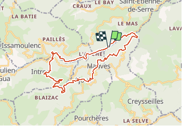

Length
18.1 km

Max alt
716 m

Uphill gradient
731 m
Km-Effort
28 km

Min alt
340 m

Downhill gradient
724 m
Boucle
Yes
Creation date :
2021-03-01 18:02:41.957
Updated on :
2021-03-01 18:03:50.104
--
Difficulty : Medium

FREE GPS app for hiking
 SityTrail
IGN / Geographical institutes
SityTrail Plus
The world is yours!
About
Trail On foot of 18.1 km to be discovered at Auvergne-Rhône-Alpes, Ardèche, Creysseilles. This trail is proposed by raygautier.
Description
moyennes plus
Positioning
Country:
France
Region :
Auvergne-Rhône-Alpes
Department/Province :
Ardèche
Municipality :
Creysseilles
Location:
Unknown
Start:(Dec)
Start:(UTM)
620134 ; 4959732 (31T) N.
Comments