


Vassieux 17 km

thonyc
User GUIDE
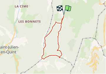

Length
12.1 km

Max alt
1619 m

Uphill gradient
532 m
Km-Effort
19.2 km

Min alt
1170 m

Downhill gradient
534 m
Boucle
Yes
Creation date :
2021-03-03 07:59:56.082
Updated on :
2021-03-03 08:14:29.61
4h00
Difficulty : Medium

FREE GPS app for hiking
 SityTrail
IGN / Geographical institutes
SityTrail Plus
The world is yours!
About
Trail Walking of 12.1 km to be discovered at Auvergne-Rhône-Alpes, Drôme, Vassieux-en-Vercors. This trail is proposed by thonyc.
Positioning
Country:
France
Region :
Auvergne-Rhône-Alpes
Department/Province :
Drôme
Municipality :
Vassieux-en-Vercors
Location:
Unknown
Start:(Dec)
Start:(UTM)
686242 ; 4970714 (31T) N.
Comments