


Barry 7km

thonyc
User GUIDE
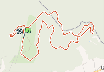

Length
8.4 km

Max alt
269 m

Uphill gradient
172 m
Km-Effort
10.7 km

Min alt
166 m

Downhill gradient
175 m
Boucle
Yes
Creation date :
2021-03-03 08:36:51.983
Updated on :
2022-04-12 15:32:22.365
3h00
Difficulty : Medium

FREE GPS app for hiking
 SityTrail
IGN / Geographical institutes
SityTrail Plus
The world is yours!
About
Trail Walking of 8.4 km to be discovered at Provence-Alpes-Côte d'Azur, Vaucluse, Bollène. This trail is proposed by thonyc.
Positioning
Country:
France
Region :
Provence-Alpes-Côte d'Azur
Department/Province :
Vaucluse
Municipality :
Bollène
Location:
Unknown
Start:(Dec)
Start:(UTM)
640337 ; 4908483 (31T) N.
Comments