


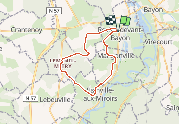
Roville devant Bayon

noelphil
User

Length
12.1 km

Max alt
353 m

Uphill gradient
248 m
Km-Effort
15.4 km

Min alt
251 m

Downhill gradient
248 m
Boucle
Yes
Creation date :
2021-03-03 12:41:01.724
Updated on :
2021-03-03 15:40:04.186
2h58
Difficulty : Very easy

FREE GPS app for hiking
 SityTrail
IGN / Geographical institutes
SityTrail Plus
The world is yours!
About
Trail Walking of 12.1 km to be discovered at Grand Est, Meurthe-et-Moselle, Roville-devant-Bayon. This trail is proposed by noelphil.
Positioning
Country:
France
Region :
Grand Est
Department/Province :
Meurthe-et-Moselle
Municipality :
Roville-devant-Bayon
Location:
Unknown
Start:(Dec)
Start:(UTM)
299763 ; 5371760 (32U) N.
Comments