


Jura pic de '' aigle

jacquesduchesne
User
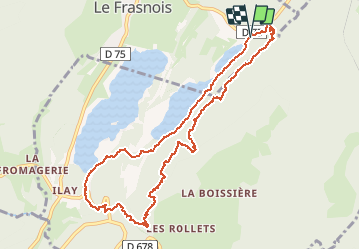

Length
10.6 km

Max alt
991 m

Uphill gradient
351 m
Km-Effort
15.3 km

Min alt
776 m

Downhill gradient
353 m
Boucle
Yes
Creation date :
2021-03-03 13:06:45.622
Updated on :
2021-03-03 16:24:24.631
3h17
Difficulty : Very easy

FREE GPS app for hiking
 SityTrail
IGN / Geographical institutes
SityTrail Plus
The world is yours!
About
Trail Walking of 10.6 km to be discovered at Bourgogne-Franche-Comté, Jura, Le Frasnois. This trail is proposed by jacquesduchesne.
Positioning
Country:
France
Region :
Bourgogne-Franche-Comté
Department/Province :
Jura
Municipality :
Le Frasnois
Location:
Unknown
Start:(Dec)
Start:(UTM)
723451 ; 5168566 (31T) N.
Comments