


Mont-Grêle-2021-03-02

Valmeinier
User
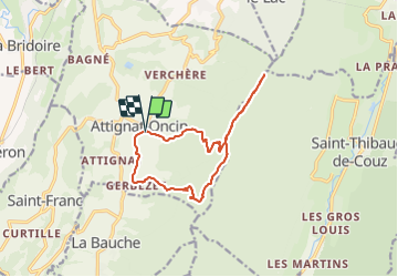

Length
13.3 km

Max alt
1434 m

Uphill gradient
871 m
Km-Effort
25 km

Min alt
599 m

Downhill gradient
865 m
Boucle
Yes
Creation date :
2021-03-03 19:06:17.101
Updated on :
2021-03-03 19:06:17.101
--
Difficulty : Unknown

FREE GPS app for hiking
 SityTrail
IGN / Geographical institutes
SityTrail Plus
The world is yours!
About
Trail Walking of 13.3 km to be discovered at Auvergne-Rhône-Alpes, Savoy, Attignat-Oncin. This trail is proposed by Valmeinier.
Positioning
Country:
France
Region :
Auvergne-Rhône-Alpes
Department/Province :
Savoy
Municipality :
Attignat-Oncin
Location:
Unknown
Start:(Dec)
Start:(UTM)
716953 ; 5042948 (31T) N.
Comments