


sarcey3

d.rognon
User

Length
13.6 km

Max alt
424 m

Uphill gradient
325 m
Km-Effort
18 km

Min alt
239 m

Downhill gradient
333 m
Boucle
Yes
Creation date :
2014-12-10 00:00:00.0
Updated on :
2014-12-10 00:00:00.0
3h47
Difficulty : Unknown

FREE GPS app for hiking
 SityTrail
IGN / Geographical institutes
SityTrail Plus
The world is yours!
About
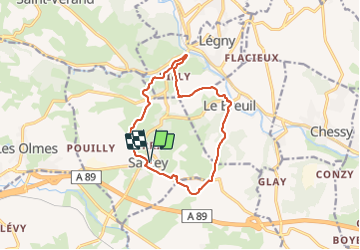
Trail Walking of 13.6 km to be discovered at Auvergne-Rhône-Alpes, Rhône, Sarcey. This trail is proposed by d.rognon.
Positioning
Country:
France
Region :
Auvergne-Rhône-Alpes
Department/Province :
Rhône
Municipality :
Sarcey
Location:
Unknown
Start:(Dec)
Start:(UTM)
621125 ; 5081868 (31T) N.
Comments