


Saint Lothain Fontenay 04 mars 2021 (IBP 73) CAF

TRIMAILLE
User


6h02
Difficulty : Medium

FREE GPS app for hiking
 SityTrail
IGN / Geographical institutes
SityTrail Plus
The world is yours!
About
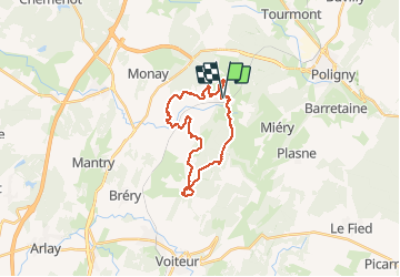
Trail Walking of 22 km to be discovered at Bourgogne-Franche-Comté, Jura, Saint-Lothain. This trail is proposed by TRIMAILLE.
Description
Départ du parking de l'abbatiale ST Taurin et du cimetière de St Lotain.
Agréable rando à travers les vignes et villages du Jura. De jolis paysages.
Visite du château de Fontenay et de la tombe de Bernard Clavel dans le cimeière qui jouxte le château.
Photos
 CAF - Photo 1")
 CAF - Photo 2")
 CAF - Photo 3")
 CAF - Photo 4")
 CAF - Photo 5")
 CAF - Photo 6")
 CAF - Photo 7")
 CAF - Photo 8")
 CAF - Photo 9")
 CAF - Photo 10")
 CAF - Photo 11")
 CAF - Photo 12")
 CAF - Photo 13")
 CAF - Photo 14")
 CAF - Photo 15")
Positioning
Comments