louvries mag

ballay
User
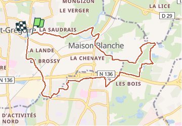

Length
11 km

Max alt
69 m

Uphill gradient
83 m
Km-Effort
12.2 km

Min alt
25 m

Downhill gradient
87 m
Boucle
Yes
Creation date :
2021-03-04 12:49:03.021
Updated on :
2021-03-04 19:05:36.977
2h28
Difficulty : Very easy

FREE GPS app for hiking
 SityTrail
IGN / Geographical institutes
SityTrail Plus
The world is yours!
About
Trail Walking of 11 km to be discovered at Brittany, Ille-et-Vilaine, Saint-Grégoire. This trail is proposed by ballay.
Description
bien pour l'hiver
Positioning
Country:
France
Region :
Brittany
Department/Province :
Ille-et-Vilaine
Municipality :
Saint-Grégoire
Location:
Unknown
Start:(Dec)
Start:(UTM)
598323 ; 5333982 (30U) N.
Comments