


GTMC J2

PhilippeC54
User

Length
59 km

Max alt
1291 m

Uphill gradient
1863 m
Km-Effort
83 km

Min alt
857 m

Downhill gradient
1526 m
Boucle
No
Creation date :
2017-06-17 00:00:00.0
Updated on :
2017-06-17 00:00:00.0
6h00
Difficulty : Medium

FREE GPS app for hiking
 SityTrail
IGN / Geographical institutes
SityTrail Plus
The world is yours!
About
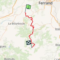
Trail Mountain bike of 59 km to be discovered at Auvergne-Rhône-Alpes, Puy-de-Dôme, Orcival. This trail is proposed by PhilippeC54.
Description
5 : Orcival - Pessade
6 : Pessade - St Victor-la-Riviere
7 : St Victor - Lac de Montcineyre
8 : Lac de Montcineyre - La Godivelle
Positioning
Country:
France
Region :
Auvergne-Rhône-Alpes
Department/Province :
Puy-de-Dôme
Municipality :
Orcival
Location:
Unknown
Start:(Dec)
Start:(UTM)
487685 ; 5058867 (31T) N.
Comments