


Villard de lans - Autrans

maupassant38
User
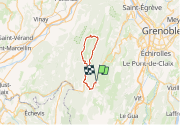

Length
38 km

Max alt
1123 m

Uphill gradient
857 m
Km-Effort
50 km

Min alt
930 m

Downhill gradient
859 m
Boucle
Yes
Creation date :
2021-03-05 09:25:01.76
Updated on :
2021-03-09 15:44:42.299
2h09
Difficulty : Medium

FREE GPS app for hiking
 SityTrail
IGN / Geographical institutes
SityTrail Plus
The world is yours!
About
Trail Mountain bike of 38 km to be discovered at Auvergne-Rhône-Alpes, Isère, Villard-de-Lans. This trail is proposed by maupassant38.
Positioning
Country:
France
Region :
Auvergne-Rhône-Alpes
Department/Province :
Isère
Municipality :
Villard-de-Lans
Location:
Unknown
Start:(Dec)
Start:(UTM)
701208 ; 4996052 (31T) N.
Comments