


Fumichon

Eve - Line
User
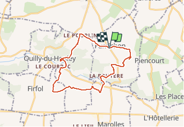

Length
13.9 km

Max alt
169 m

Uphill gradient
188 m
Km-Effort
16.4 km

Min alt
91 m

Downhill gradient
188 m
Boucle
Yes
Creation date :
2021-03-06 08:03:38.753
Updated on :
2021-03-06 10:47:31.801
2h43
Difficulty : Medium

FREE GPS app for hiking
 SityTrail
IGN / Geographical institutes
SityTrail Plus
The world is yours!
About
Trail Walking of 13.9 km to be discovered at Normandy, Calvados, Fumichon. This trail is proposed by Eve - Line.
Photos


39 photos in total. Please click on a photo to see them all in the gallery.
Positioning
Country:
France
Region :
Normandy
Department/Province :
Calvados
Municipality :
Fumichon
Location:
Unknown
Start:(Dec)
Start:(UTM)
308412 ; 5449976 (31U) N.
Comments
Superbe parcours avec nos enfants - totalement dépaysés.