


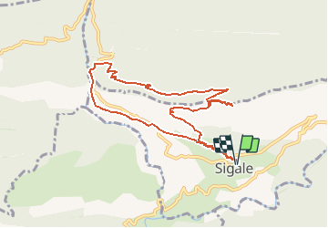
bois de la CACIA et gorge du RIOLAN au départ de SIgale en boucle

Benteux
User

Length
9.3 km

Max alt
1087 m

Uphill gradient
645 m
Km-Effort
17.9 km

Min alt
591 m

Downhill gradient
639 m
Boucle
Yes
Creation date :
2021-03-07 08:44:54.376
Updated on :
2021-03-07 09:18:17.604
4h05
Difficulty : Medium

FREE GPS app for hiking
 SityTrail
IGN / Geographical institutes
SityTrail Plus
The world is yours!
About
Trail Walking of 9.3 km to be discovered at Provence-Alpes-Côte d'Azur, Maritime Alps, Sigale. This trail is proposed by Benteux.
Description
Cime de la CACIA optionnel (150m de dénivelé) - 500m du parcours sur goudron pour voir les gorges du Riolan.
Positioning
Country:
France
Region :
Provence-Alpes-Côte d'Azur
Department/Province :
Maritime Alps
Municipality :
Sigale
Location:
Unknown
Start:(Dec)
Start:(UTM)
336483 ; 4859678 (32T) N.
Comments
belle montée avec vue sur les vautours