


chenedet st francois 9km

coglais
User
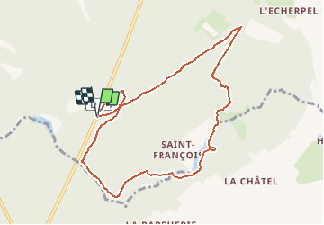

Length
9 km

Max alt
209 m

Uphill gradient
148 m
Km-Effort
11 km

Min alt
149 m

Downhill gradient
146 m
Boucle
Yes
Creation date :
2021-03-07 18:15:04.669
Updated on :
2021-03-07 18:16:29.44
2h00
Difficulty : Easy

FREE GPS app for hiking
 SityTrail
IGN / Geographical institutes
SityTrail Plus
The world is yours!
About
Trail Nordic walking of 9 km to be discovered at Brittany, Ille-et-Vilaine, Landéan. This trail is proposed by coglais.
Positioning
Country:
France
Region :
Brittany
Department/Province :
Ille-et-Vilaine
Municipality :
Landéan
Location:
Unknown
Start:(Dec)
Start:(UTM)
635946 ; 5361671 (30U) N.
Comments