


Anlier

pierlan
User
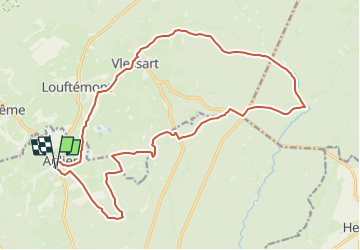

Length
19.8 km

Max alt
497 m

Uphill gradient
371 m
Km-Effort
25 km

Min alt
423 m

Downhill gradient
375 m
Boucle
Yes
Creation date :
2021-03-08 09:31:11.042
Updated on :
2023-03-31 16:13:11.771
4h00
Difficulty : Medium

FREE GPS app for hiking
 SityTrail
IGN / Geographical institutes
SityTrail Plus
The world is yours!
About
Trail Trail of 19.8 km to be discovered at Wallonia, Luxembourg, Habay. This trail is proposed by pierlan.
Positioning
Country:
Belgium
Region :
Wallonia
Department/Province :
Luxembourg
Municipality :
Habay
Location:
Anlier
Start:(Dec)
Start:(UTM)
688678 ; 5516469 (31U) N.
Comments