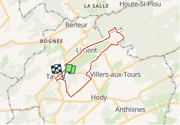
AS06 Boucle des Sarts

Trails in Esneux
Discover trails in Esneux GUIDE+

Length
10.9 km

Max alt
283 m

Uphill gradient
200 m
Km-Effort
13.5 km

Min alt
181 m

Downhill gradient
191 m
Boucle
Yes
Creation date :
2021-03-08 10:52:21.74
Updated on :
2021-03-08 10:56:30.191
3h00
Difficulty : Medium
1h00
Difficulty : Easy

FREE GPS app for hiking
 SityTrail
IGN / Geographical institutes
SityTrail Plus
The world is yours!
About
Trail On foot of 10.9 km to be discovered at Wallonia, Liège, Anthisnes. This trail is proposed by Trails in Esneux.
Description
Suivez le balisage Losange Vert.
Positioning
Country:
Belgium
Region :
Wallonia
Department/Province :
Liège
Municipality :
Anthisnes
Location:
Tavier
Start:(Dec)
Start:(UTM)
675639 ; 5596544 (31U) N.
Comments