


Rayol Col de l'étoile et des tuiles

Patrick Lemaire
User
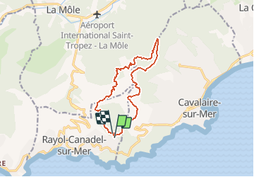

Length
13.3 km

Max alt
524 m

Uphill gradient
679 m
Km-Effort
22 km

Min alt
68 m

Downhill gradient
705 m
Boucle
Yes
Creation date :
2021-03-08 15:42:03.689
Updated on :
2021-03-08 15:43:27.313
5h05
Difficulty : Medium

FREE GPS app for hiking
 SityTrail
IGN / Geographical institutes
SityTrail Plus
The world is yours!
About
Trail On foot of 13.3 km to be discovered at Provence-Alpes-Côte d'Azur, Var, Rayol-Canadel-sur-Mer. This trail is proposed by Patrick Lemaire.
Positioning
Country:
France
Region :
Provence-Alpes-Côte d'Azur
Department/Province :
Var
Municipality :
Rayol-Canadel-sur-Mer
Location:
Unknown
Start:(Dec)
Start:(UTM)
296000 ; 4781848 (32T) N.
Comments