


Duniere les eyrieux

raygautier
User
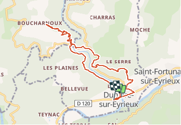

Length
10.5 km

Max alt
467 m

Uphill gradient
510 m
Km-Effort
17.3 km

Min alt
150 m

Downhill gradient
518 m
Boucle
No
Creation date :
2021-03-08 10:25:04.0
Updated on :
2021-03-08 17:56:37.943
5h22
Difficulty : Unknown

FREE GPS app for hiking
 SityTrail
IGN / Geographical institutes
SityTrail Plus
The world is yours!
About
Trail Walking of 10.5 km to be discovered at Auvergne-Rhône-Alpes, Ardèche, Dunière-sur-Eyrieux. This trail is proposed by raygautier.
Positioning
Country:
France
Region :
Auvergne-Rhône-Alpes
Department/Province :
Ardèche
Municipality :
Dunière-sur-Eyrieux
Location:
Unknown
Start:(Dec)
Start:(UTM)
631011 ; 4964544 (31T) N.
Comments