


FROMIEE

MITCHE2020
User
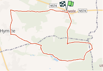

Length
10.9 km

Max alt
272 m

Uphill gradient
180 m
Km-Effort
13.3 km

Min alt
199 m

Downhill gradient
180 m
Boucle
Yes
Creation date :
2021-03-09 10:25:22.367
Updated on :
2021-03-09 10:26:07.451
3h01
Difficulty : Difficult

FREE GPS app for hiking
 SityTrail
IGN / Geographical institutes
SityTrail Plus
The world is yours!
About
Trail Walking of 10.9 km to be discovered at Wallonia, Hainaut, Gerpinnes. This trail is proposed by MITCHE2020.
Positioning
Country:
Belgium
Region :
Wallonia
Department/Province :
Hainaut
Municipality :
Gerpinnes
Location:
Gerpinnes
Start:(Dec)
Start:(UTM)
612144 ; 5576859 (31U) N.
Comments