


Le bec pointu

raygautier
User

Length
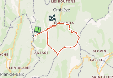
14.3 km

Max alt
1317 m

Uphill gradient
993 m
Km-Effort
27 km

Min alt
604 m

Downhill gradient
968 m
Boucle
No
Creation date :
2021-03-09 09:48:48.0
Updated on :
2021-03-09 15:32:25.533
5h41
Difficulty : Unknown

FREE GPS app for hiking
 SityTrail
IGN / Geographical institutes
SityTrail Plus
The world is yours!
About
Trail Walking of 14.3 km to be discovered at Auvergne-Rhône-Alpes, Drôme, Omblèze. This trail is proposed by raygautier.
Positioning
Country:
France
Region :
Auvergne-Rhône-Alpes
Department/Province :
Drôme
Municipality :
Omblèze
Location:
Unknown
Start:(Dec)
Start:(UTM)
673034 ; 4967736 (31T) N.
Comments