


Givry JC

LUCIE2016
User

Length
17.6 km

Max alt
435 m

Uphill gradient
594 m
Km-Effort
26 km

Min alt
224 m

Downhill gradient
594 m
Boucle
Yes
Creation date :
2021-03-09 12:15:12.015
Updated on :
2021-03-09 16:30:02.221
4h13
Difficulty : Very easy

FREE GPS app for hiking
 SityTrail
IGN / Geographical institutes
SityTrail Plus
The world is yours!
About
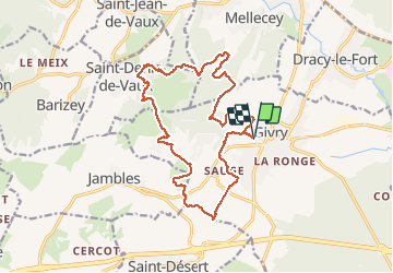
Trail Walking of 17.6 km to be discovered at Bourgogne-Franche-Comté, Saône-et-Loire, Givry. This trail is proposed by LUCIE2016.
Description
G1
Positioning
Country:
France
Region :
Bourgogne-Franche-Comté
Department/Province :
Saône-et-Loire
Municipality :
Givry
Location:
Unknown
Start:(Dec)
Start:(UTM)
632664 ; 5182361 (31T) N.
Comments