


La vallée de l auzéne 2

raygautier
User
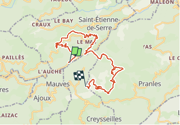

Length
19 km

Max alt
803 m

Uphill gradient
901 m
Km-Effort
30 km

Min alt
340 m

Downhill gradient
690 m
Boucle
No
Creation date :
2021-03-10 07:10:56.0
Updated on :
2021-03-10 19:23:54.18
7h27
Difficulty : Unknown

FREE GPS app for hiking
 SityTrail
IGN / Geographical institutes
SityTrail Plus
The world is yours!
About
Trail Walking of 19 km to be discovered at Auvergne-Rhône-Alpes, Ardèche, Saint-Étienne-de-Serre. This trail is proposed by raygautier.
Positioning
Country:
France
Region :
Auvergne-Rhône-Alpes
Department/Province :
Ardèche
Municipality :
Saint-Étienne-de-Serre
Location:
Unknown
Start:(Dec)
Start:(UTM)
620194 ; 4959895 (31T) N.
Comments