


ST MARTIN DE LA CLUZE

maupassant38
User
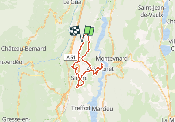

Length
25 km

Max alt
943 m

Uphill gradient
760 m
Km-Effort
35 km

Min alt
489 m

Downhill gradient
756 m
Boucle
Yes
Creation date :
2021-03-11 09:34:08.452
Updated on :
2021-03-11 12:26:16.123
1h50
Difficulty : Medium

FREE GPS app for hiking
 SityTrail
IGN / Geographical institutes
SityTrail Plus
The world is yours!
About
Trail Mountain bike of 25 km to be discovered at Auvergne-Rhône-Alpes, Isère, Saint-Martin-de-la-Cluze. This trail is proposed by maupassant38.
Positioning
Country:
France
Region :
Auvergne-Rhône-Alpes
Department/Province :
Isère
Municipality :
Saint-Martin-de-la-Cluze
Location:
Unknown
Start:(Dec)
Start:(UTM)
709703 ; 4984396 (31T) N.
Comments