


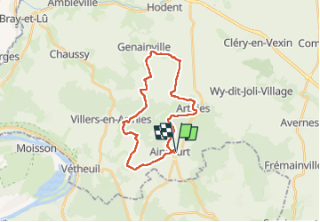
Aincourt, Arthies et Genainville

philberard95
User

Length
24 km

Max alt
211 m

Uphill gradient
374 m
Km-Effort
29 km

Min alt
92 m

Downhill gradient
374 m
Boucle
Yes
Creation date :
2021-03-11 08:54:05.264
Updated on :
2023-01-11 10:53:48.631
5h48
Difficulty : Very easy

FREE GPS app for hiking
 SityTrail
IGN / Geographical institutes
SityTrail Plus
The world is yours!
About
Trail Walking of 24 km to be discovered at Ile-de-France, Val-d'Oise, Aincourt. This trail is proposed by philberard95.
Positioning
Country:
France
Region :
Ile-de-France
Department/Province :
Val-d'Oise
Municipality :
Aincourt
Location:
Unknown
Start:(Dec)
Start:(UTM)
410670 ; 5436165 (31U) N.
Comments