


Jastres louyres

raab
User
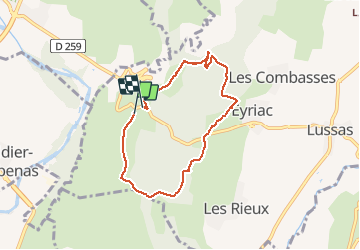

Length
6.6 km

Max alt
344 m

Uphill gradient
81 m
Km-Effort
7.7 km

Min alt
301 m

Downhill gradient
76 m
Boucle
Yes
Creation date :
2021-03-11 13:19:18.408
Updated on :
2021-03-11 15:46:56.709
2h27
Difficulty : Medium

FREE GPS app for hiking
 SityTrail
IGN / Geographical institutes
SityTrail Plus
The world is yours!
About
Trail Walking of 6.6 km to be discovered at Auvergne-Rhône-Alpes, Ardèche, Lussas. This trail is proposed by raab.
Positioning
Country:
France
Region :
Auvergne-Rhône-Alpes
Department/Province :
Ardèche
Municipality :
Lussas
Location:
Unknown
Start:(Dec)
Start:(UTM)
614221 ; 4941025 (31T) N.
Comments