


Sainte Hélène le bois de Chazeuil page 50

grasgilbert
User
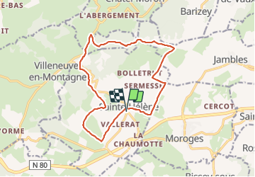

Length
15.2 km

Max alt
498 m

Uphill gradient
307 m
Km-Effort
19.3 km

Min alt
302 m

Downhill gradient
307 m
Boucle
Yes
Creation date :
2021-03-12 11:25:55.766
Updated on :
2021-08-05 15:10:27.752
3h28
Difficulty : Medium

FREE GPS app for hiking
 SityTrail
IGN / Geographical institutes
SityTrail Plus
The world is yours!
About
Trail Walking of 15.2 km to be discovered at Bourgogne-Franche-Comté, Saône-et-Loire, Sainte-Hélène. This trail is proposed by grasgilbert.
Positioning
Country:
France
Region :
Bourgogne-Franche-Comté
Department/Province :
Saône-et-Loire
Municipality :
Sainte-Hélène
Location:
Unknown
Start:(Dec)
Start:(UTM)
625501 ; 5179314 (31T) N.
Comments
bien