


titinechris

Titinechris
User
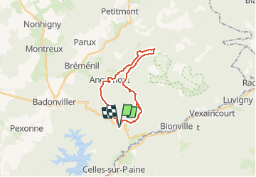

Length
20 km

Max alt
563 m

Uphill gradient
534 m
Km-Effort
27 km

Min alt
340 m

Downhill gradient
536 m
Boucle
Yes
Creation date :
2021-03-13 07:36:42.617
Updated on :
2021-03-13 13:55:56.91
--
Difficulty : Easy

FREE GPS app for hiking
 SityTrail
IGN / Geographical institutes
SityTrail Plus
The world is yours!
About
Trail Trail of 20 km to be discovered at Grand Est, Meurthe-et-Moselle, Angomont. This trail is proposed by Titinechris.
Description
Roche aux sourcils
Positioning
Country:
France
Region :
Grand Est
Department/Province :
Meurthe-et-Moselle
Municipality :
Angomont
Location:
Unknown
Start:(Dec)
Start:(UTM)
349009 ; 5372135 (32U) N.
Comments