


30 CALVISSON les moulins 20210314

papagenopier
User

Length
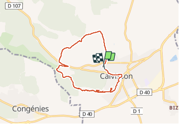
7.3 km

Max alt
159 m

Uphill gradient
155 m
Km-Effort
9.3 km

Min alt
59 m

Downhill gradient
155 m
Boucle
Yes
Creation date :
2021-03-14 10:27:47.801
Updated on :
2021-03-14 13:01:05.979
2h08
Difficulty : Very easy

FREE GPS app for hiking
 SityTrail
IGN / Geographical institutes
SityTrail Plus
The world is yours!
About
Trail Walking of 7.3 km to be discovered at Occitania, Gard, Calvisson. This trail is proposed by papagenopier.
Photos


Positioning
Country:
France
Region :
Occitania
Department/Province :
Gard
Municipality :
Calvisson
Location:
Unknown
Start:(Dec)
Start:(UTM)
595387 ; 4848969 (31T) N.
Comments
Facile et agreable