


Orcines Ternant

jeanic63
User
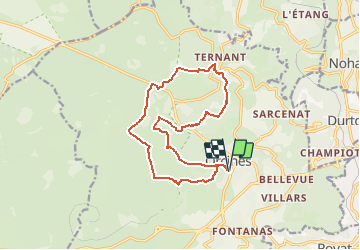

Length
15.2 km

Max alt
1006 m

Uphill gradient
322 m
Km-Effort
19.5 km

Min alt
830 m

Downhill gradient
317 m
Boucle
Yes
Creation date :
2021-03-15 17:49:55.086
Updated on :
2021-03-25 19:37:35.609
3h56
Difficulty : Medium

FREE GPS app for hiking
 SityTrail
IGN / Geographical institutes
SityTrail Plus
The world is yours!
About
Trail On foot of 15.2 km to be discovered at Auvergne-Rhône-Alpes, Puy-de-Dôme, Orcines. This trail is proposed by jeanic63.
Description
départ eglise d'Orcines
Positioning
Country:
France
Region :
Auvergne-Rhône-Alpes
Department/Province :
Puy-de-Dôme
Municipality :
Orcines
Location:
Unknown
Start:(Dec)
Start:(UTM)
500911 ; 5069918 (31T) N.
Comments