


TOURNEUR VRAI:11:41 001

UDGI54
User
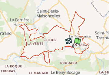

Length
28 km

Max alt
216 m

Uphill gradient
596 m
Km-Effort
35 km

Min alt
80 m

Downhill gradient
592 m
Boucle
Yes
Creation date :
2021-03-16 13:45:56.355
Updated on :
2021-03-16 13:50:19.88

FREE GPS app for hiking
 SityTrail
IGN / Geographical institutes
SityTrail Plus
The world is yours!
About
Trail of 28 km to be discovered at Normandy, Calvados, Souleuvre-en-Bocage. This trail is proposed by UDGI54.
Positioning
Country:
France
Region :
Normandy
Department/Province :
Calvados
Municipality :
Souleuvre-en-Bocage
Location:
Le Tourneur
Start:(Dec)
Start:(UTM)
658857 ; 5424784 (30U) N.
Comments