


16 mars 21 belvédère des crêtes

ocharra
User
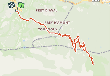

Length
12.6 km

Max alt
2028 m

Uphill gradient
454 m
Km-Effort
18.6 km

Min alt
1676 m

Downhill gradient
456 m
Boucle
Yes
Creation date :
2021-03-16 10:03:00.061
Updated on :
2021-03-16 15:50:28.751
3h33
Difficulty : Medium

FREE GPS app for hiking
 SityTrail
IGN / Geographical institutes
SityTrail Plus
The world is yours!
About
Trail Walking of 12.6 km to be discovered at Provence-Alpes-Côte d'Azur, Hautes-Alpes, Puy-Saint-Vincent. This trail is proposed by ocharra.
Positioning
Country:
France
Region :
Provence-Alpes-Côte d'Azur
Department/Province :
Hautes-Alpes
Municipality :
Puy-Saint-Vincent
Location:
Unknown
Start:(Dec)
Start:(UTM)
301249 ; 4965862 (32T) N.
Comments