


mondragon

losjo
User
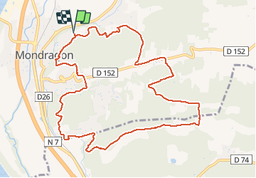

Length
12.7 km

Max alt
151 m

Uphill gradient
252 m
Km-Effort
16 km

Min alt
47 m

Downhill gradient
251 m
Boucle
Yes
Creation date :
2021-03-16 13:00:30.433
Updated on :
2021-03-16 16:18:56.396
3h17
Difficulty : Very easy

FREE GPS app for hiking
 SityTrail
IGN / Geographical institutes
SityTrail Plus
The world is yours!
About
Trail Walking of 12.7 km to be discovered at Provence-Alpes-Côte d'Azur, Vaucluse, Mondragon. This trail is proposed by losjo.
Positioning
Country:
France
Region :
Provence-Alpes-Côte d'Azur
Department/Province :
Vaucluse
Municipality :
Mondragon
Location:
Unknown
Start:(Dec)
Start:(UTM)
637384 ; 4900216 (31T) N.
Comments