


Pont de Veyle Crottet StJean/V PDV

janussity
User
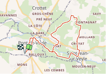

Length
10.5 km

Max alt
209 m

Uphill gradient
74 m
Km-Effort
11.5 km

Min alt
172 m

Downhill gradient
74 m
Boucle
Yes
Creation date :
2021-03-16 13:32:09.997
Updated on :
2021-03-16 16:27:43.303
2h30
Difficulty : Easy

FREE GPS app for hiking
 SityTrail
IGN / Geographical institutes
SityTrail Plus
The world is yours!
About
Trail Walking of 10.5 km to be discovered at Auvergne-Rhône-Alpes, Ain, Pont-de-Veyle. This trail is proposed by janussity.
Description
Passage bordé de maisons.
Belle promenade sur asphalte et chemin de terre.
Positioning
Country:
France
Region :
Auvergne-Rhône-Alpes
Department/Province :
Ain
Municipality :
Pont-de-Veyle
Location:
Unknown
Start:(Dec)
Start:(UTM)
645222 ; 5124575 (31T) N.
Comments
inondations au retour.Deviation