


La sortie du 20/03/2021

choumac08
User
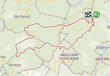

Length
20 km

Max alt
393 m

Uphill gradient
634 m
Km-Effort
29 km

Min alt
133 m

Downhill gradient
630 m
Boucle
Yes
Creation date :
2021-03-16 19:20:08.598
Updated on :
2021-03-16 19:54:49.958
3h40
Difficulty : Medium

FREE GPS app for hiking
 SityTrail
IGN / Geographical institutes
SityTrail Plus
The world is yours!
About
Trail Trail of 20 km to be discovered at Grand Est, Ardennes, Bogny-sur-Meuse. This trail is proposed by choumac08.
Positioning
Country:
France
Region :
Grand Est
Department/Province :
Ardennes
Municipality :
Bogny-sur-Meuse
Location:
Unknown
Start:(Dec)
Start:(UTM)
625034 ; 5524139 (31U) N.
Comments