


Randonnée à Charneux

tatous
User
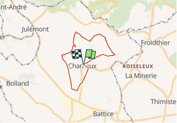

Length
9.9 km

Max alt
272 m

Uphill gradient
211 m
Km-Effort
12.7 km

Min alt
182 m

Downhill gradient
207 m
Boucle
Yes
Creation date :
2021-03-17 14:20:05.259
Updated on :
2021-03-20 13:52:05.194
3h05
Difficulty : Difficult

FREE GPS app for hiking
 SityTrail
IGN / Geographical institutes
SityTrail Plus
The world is yours!
About
Trail Walking of 9.9 km to be discovered at Wallonia, Liège, Herve. This trail is proposed by tatous.
Positioning
Country:
Belgium
Region :
Wallonia
Department/Province :
Liège
Municipality :
Herve
Location:
Charneux
Start:(Dec)
Start:(UTM)
698268 ; 5616841 (31U) N.
Comments