


Anloy

pierlan
User
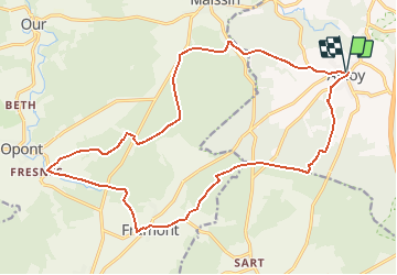

Length
19.6 km

Max alt
457 m

Uphill gradient
343 m
Km-Effort
24 km

Min alt
339 m

Downhill gradient
346 m
Boucle
Yes
Creation date :
2021-03-20 10:10:24.217
Updated on :
2021-03-20 10:11:15.238
4h00
Difficulty : Very easy

FREE GPS app for hiking
 SityTrail
IGN / Geographical institutes
SityTrail Plus
The world is yours!
About
Trail Trail of 19.6 km to be discovered at Wallonia, Luxembourg, Libin. This trail is proposed by pierlan.
Positioning
Country:
Belgium
Region :
Wallonia
Department/Province :
Luxembourg
Municipality :
Libin
Location:
Anloy
Start:(Dec)
Start:(UTM)
659377 ; 5535462 (31U) N.
Comments