


Amicale_Valsonne_16_3

d.rognon
User
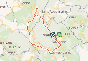

Length
15.6 km

Max alt
845 m

Uphill gradient
518 m
Km-Effort
22 km

Min alt
440 m

Downhill gradient
520 m
Boucle
Yes
Creation date :
2021-03-20 12:50:52.915
Updated on :
2024-10-21 14:52:40.77
5h06
Difficulty : Very difficult

FREE GPS app for hiking
 SityTrail
IGN / Geographical institutes
SityTrail Plus
The world is yours!
About
Trail Walking of 15.6 km to be discovered at Auvergne-Rhône-Alpes, Rhône, Valsonne. This trail is proposed by d.rognon.
Positioning
Country:
France
Region :
Auvergne-Rhône-Alpes
Department/Province :
Rhône
Municipality :
Valsonne
Location:
Unknown
Start:(Dec)
Start:(UTM)
610593 ; 5089301 (31T) N.
Comments