


valmasq

fab4u
User
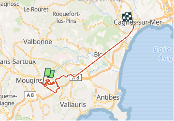

Length
22 km

Max alt
233 m

Uphill gradient
486 m
Km-Effort
29 km

Min alt
5 m

Downhill gradient
683 m
Boucle
No
Creation date :
2021-03-20 10:59:19.062
Updated on :
2021-03-20 14:20:26.182
3h05
Difficulty : Very easy

FREE GPS app for hiking
 SityTrail
IGN / Geographical institutes
SityTrail Plus
The world is yours!
About
Trail Nordic walking of 22 km to be discovered at Provence-Alpes-Côte d'Azur, Maritime Alps, Mougins. This trail is proposed by fab4u.
Positioning
Country:
France
Region :
Provence-Alpes-Côte d'Azur
Department/Province :
Maritime Alps
Municipality :
Mougins
Location:
Unknown
Start:(Dec)
Start:(UTM)
339908 ; 4829049 (32T) N.
Comments