


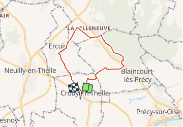
Crouy le colin galant

Djaie60
User

Length
11.4 km

Max alt
148 m

Uphill gradient
169 m
Km-Effort
13.7 km

Min alt
67 m

Downhill gradient
170 m
Boucle
Yes
Creation date :
2021-03-20 22:36:48.0
Updated on :
2021-03-21 08:26:15.629
3h05
Difficulty : Easy

FREE GPS app for hiking
 SityTrail
IGN / Geographical institutes
SityTrail Plus
The world is yours!
About
Trail On foot of 11.4 km to be discovered at Hauts-de-France, Oise, Crouy-en-Thelle. This trail is proposed by Djaie60.
Positioning
Country:
France
Region :
Hauts-de-France
Department/Province :
Oise
Municipality :
Crouy-en-Thelle
Location:
Unknown
Start:(Dec)
Start:(UTM)
450453 ; 5451286 (31U) N.
Comments