


GRP571_Parcours-principal_2019-07-03

Em55
User
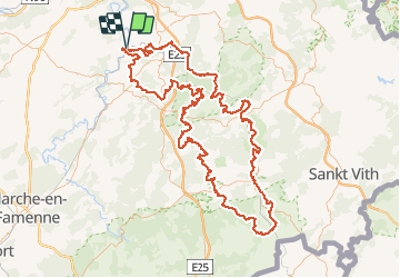

Length
186 km

Max alt
579 m

Uphill gradient
5268 m
Km-Effort
257 km

Min alt
97 m

Downhill gradient
5270 m
Boucle
Yes
Creation date :
2021-03-21 13:03:32.519
Updated on :
2021-05-18 07:50:03.94
58h17
Difficulty : Very difficult

FREE GPS app for hiking
 SityTrail
IGN / Geographical institutes
SityTrail Plus
The world is yours!
About
Trail Walking of 186 km to be discovered at Wallonia, Liège, Comblain-au-Pont. This trail is proposed by Em55.

Positioning
Country:
Belgium
Region :
Wallonia
Department/Province :
Liège
Municipality :
Comblain-au-Pont
Location:
Comblain-au-Pont
Start:(Dec)
Start:(UTM)
683731 ; 5595171 (31U) N.
Comments