


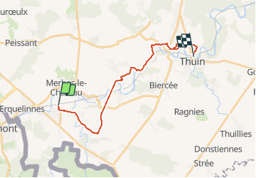
Solre-sur-Sambre - Thuin

artnoe
User

Length
18.6 km

Max alt
189 m

Uphill gradient
291 m
Km-Effort
23 km

Min alt
112 m

Downhill gradient
293 m
Boucle
No
Creation date :
2021-03-21 09:48:48.0
Updated on :
2021-03-21 14:20:39.203
3h29
Difficulty : Unknown

FREE GPS app for hiking
 SityTrail
IGN / Geographical institutes
SityTrail Plus
The world is yours!
About
Trail Walking of 18.6 km to be discovered at Wallonia, Hainaut, Erquelinnes. This trail is proposed by artnoe.
Description
De gare à gare
Positioning
Country:
Belgium
Region :
Wallonia
Department/Province :
Hainaut
Municipality :
Erquelinnes
Location:
Solre-sur-Sambre
Start:(Dec)
Start:(UTM)
582399 ; 5574019 (31U) N.
Comments