Trail Walking Vif - Circuit entre Vif et les sources de l'Echaillon par la cabane d'Uriol avec retour par Champrond - Photo

Circuit entre Vif et les sources de l'Echaillon par la cabane d'Uriol avec retour par Champrond

 Emelle
Emelle

User

© OpenStreetMap contributors
Length
Length
12.5 km
Max alt
Max alt
915 m
Uphill gradient
Uphill gradient
674 m
Km-Effort
Km-Effort  
21 km
Min alt
Min alt
310 m
Downhill gradient
Downhill gradient
675 m
Boucle
Boucle
Yes
Creation date :
2021-03-21 07:43:48.629
Updated on :
2021-03-21 16:42:21.889

(0 Reviews)

Walking
Walking
6h03
Difficulty : Medium

Scan this QR Code to open this trail in the SityTrail application

FREE GPS app for hiking

Logo SityTrail SityTrail

IGN / Geographical institutes

Download SityTrail from the App Store Download SityTrail from Google Play

Logo SityTrail SityTrail World

The world is yours!

Download SityTrail from the App Store Download SityTrail from Google Play Download SityTrail on Huawei AppGallery

About

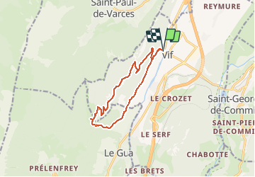
Trail Walking of 12.5 km to be discovered at Auvergne-Rhône-Alpes, Isère, Vif. This trail is proposed by Emelle.

Description

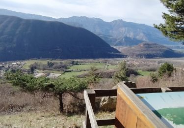
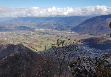
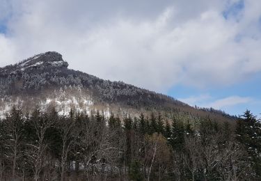
Très beau circuit sans difficulté par une belle journée printanière avec de beaux points de vue sur les massifs environnants.
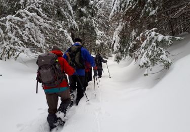
Découverte d'un petit diverticule hors sentier balisé qui arrive un peu avant la cabane d'Uriol.
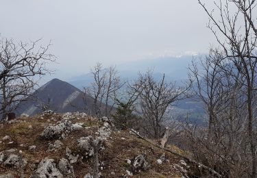
Pique-nique au soleil sous l'arête sud qui mène au sommet du Pieu.
Retour par Champrond par un sentier non balisé mais bien sur la carte.
Les 2 derniers dos d'âne à la fin peuvent impressionner mais finalement se passent sans difficultés.

Elevation profile

Photos

Positioning

Country:
France
Region :
Auvergne-Rhône-Alpes
Department/Province :
Isère
Municipality :
Vif
Location:
Unknown
Start:(UTM)
709992 ; 4992700 (31T) N.

Trails nearby

Trail Walking Varces-Allières-et-Risset - Les Etangs de Reymure réaménagés en 2023. - Photo
Walking
patjobou

Walking

Medium
Varces-Allières-et-Risset, Auvergne-Rhône-Alpes, Isère, France
7.9 km | 8.6 km-effort
2h 35min
Yes
Trail Walking Vif - la ferme oriol en circuit  - Photo
Walking
Youcef Atallah

Walking

Very difficult
Vif, Auvergne-Rhône-Alpes, Isère, France
13.7 km | 24 km-effort
3h 15min
Yes
Trail Walking Saint-Georges-de-Commiers - Boucle autour de Saint Georges de Commiers - Photo
Walking
permanent 31

Walking

Difficult
Saint-Georges-de-Commiers, Auvergne-Rhône-Alpes, Isère, France
8.2 km | 12 km-effort
2h 26min
No
Trail Walking Le Gua - Un tour de L'Eperrimont par le sommet ! - Photo
Walking
patjobou

Walking

Medium
Le Gua, Auvergne-Rhône-Alpes, Isère, France
14.6 km | 27 km-effort
6h 5min
Yes
Trail Walking Le Gua - Le Pieu depuis Les Petits Amieux - Photo
Walking
patjobou

Walking

Medium
Le Gua, Auvergne-Rhône-Alpes, Isère, France
11.8 km | 22 km-effort
4h 54min
Yes
Trail Nordic walking Vif - Les Etangs de la Plaine de Reymure - Photo
Nordic walking
patjobou

Nordic walking

Easy
Vif, Auvergne-Rhône-Alpes, Isère, France
9.4 km | 10.3 km-effort
2h 0min
Yes
Trail Nordic walking Varces-Allières-et-Risset - De la plaine de  Reymure au canal de Malissolles - Photo
Nordic walking
patjobou

Nordic walking

Easy
Varces-Allières-et-Risset, Auvergne-Rhône-Alpes, Isère, France
9.1 km | 10.3 km-effort
2h 1min
Yes
Trail Walking Le Gua - L'Eperrimont  ou l'Indien en mode hivernal - Photo
Walking
patjobou

Walking

Difficult
Le Gua, Auvergne-Rhône-Alpes, Isère, France
7.4 km | 13.6 km-effort
3h 9min
Yes
Trail Walking Le Gua - Epérimont - Photo
Walking
Emelle

Walking

Medium
Le Gua, Auvergne-Rhône-Alpes, Isère, France
7.4 km | 13.5 km-effort
5h 45min
Yes


Close
My subscriptions