


verfeuil la bastide

ajasse
User
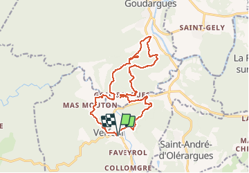

Length
18.3 km

Max alt
214 m

Uphill gradient
472 m
Km-Effort
25 km

Min alt
82 m

Downhill gradient
470 m
Boucle
Yes
Creation date :
2021-03-22 07:58:07.722
Updated on :
2021-03-22 14:49:58.489
4h58
Difficulty : Easy

FREE GPS app for hiking
 SityTrail
IGN / Geographical institutes
SityTrail Plus
The world is yours!
About
Trail Walking of 18.3 km to be discovered at Occitania, Gard, Verfeuil. This trail is proposed by ajasse.
Positioning
Country:
France
Region :
Occitania
Department/Province :
Gard
Municipality :
Verfeuil
Location:
Unknown
Start:(Dec)
Start:(UTM)
616090 ; 4891550 (31T) N.
Comments
Merci .