


saulzet le chaud la tour de montrognon

jeanic63
User

Length
13.5 km

Max alt
827 m

Uphill gradient
510 m
Km-Effort
20 km

Min alt
499 m

Downhill gradient
510 m
Boucle
Yes
Creation date :
2021-03-22 18:16:19.211
Updated on :
2021-03-22 18:19:28.949
4h36
Difficulty : Medium

FREE GPS app for hiking
 SityTrail
IGN / Geographical institutes
SityTrail Plus
The world is yours!
About
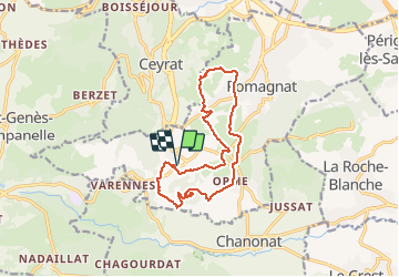
Trail On foot of 13.5 km to be discovered at Auvergne-Rhône-Alpes, Puy-de-Dôme, Romagnat. This trail is proposed by jeanic63.
Description
départ cimetière de Saulzet le caud rue des frénes
Positioning
Country:
France
Region :
Auvergne-Rhône-Alpes
Department/Province :
Puy-de-Dôme
Municipality :
Romagnat
Location:
Unknown
Start:(Dec)
Start:(UTM)
505635 ; 5061899 (31T) N.
Comments