


Sentier de hallage. Bouzies

fb30
User
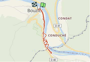

Length
3.6 km

Max alt
203 m

Uphill gradient
145 m
Km-Effort
5.5 km

Min alt
127 m

Downhill gradient
145 m
Boucle
Yes
Creation date :
2021-03-23 09:44:32.0
Updated on :
2021-03-29 11:24:16.358
1h09
Difficulty :

FREE GPS app for hiking
 SityTrail
IGN / Geographical institutes
SityTrail Plus
The world is yours!
About
Trail Walking of 3.6 km to be discovered at Occitania, Lot, Bouziès. This trail is proposed by fb30.
Positioning
Country:
France
Region :
Occitania
Department/Province :
Lot
Municipality :
Bouziès
Location:
Unknown
Start:(Dec)
Start:(UTM)
392198 ; 4926532 (31T) N.
Comments