


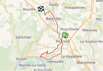
roumarebarentin

dedejojo
User

Length
22 km

Max alt
134 m

Uphill gradient
356 m
Km-Effort
27 km

Min alt
6 m

Downhill gradient
359 m
Boucle
No
Creation date :
2021-03-23 12:23:35.059
Updated on :
2021-03-23 17:31:09.155
5h06
Difficulty : Very easy

FREE GPS app for hiking
 SityTrail
IGN / Geographical institutes
SityTrail Plus
The world is yours!
About
Trail Walking of 22 km to be discovered at Normandy, Seine-Maritime, Roumare. This trail is proposed by dedejojo.
Positioning
Country:
France
Region :
Normandy
Department/Province :
Seine-Maritime
Municipality :
Roumare
Location:
Unknown
Start:(Dec)
Start:(UTM)
353198 ; 5486113 (31U) N.
Comments