


2021-03-23 16:42:14

Monjean
User

Length
18.6 km

Max alt
730 m

Uphill gradient
766 m
Km-Effort
29 km

Min alt
257 m

Downhill gradient
771 m
Boucle
Yes
Creation date :
2021-03-23 18:58:07.786
Updated on :
2021-03-23 19:06:08.88
6h33
Difficulty : Very difficult

FREE GPS app for hiking
 SityTrail
IGN / Geographical institutes
SityTrail Plus
The world is yours!
About
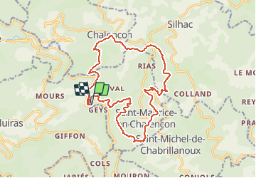
Trail Walking of 18.6 km to be discovered at Auvergne-Rhône-Alpes, Ardèche, Saint-Maurice-en-Chalencon. This trail is proposed by Monjean.
Positioning
Country:
France
Region :
Auvergne-Rhône-Alpes
Department/Province :
Ardèche
Municipality :
Saint-Maurice-en-Chalencon
Location:
Unknown
Start:(Dec)
Start:(UTM)
623630 ; 4967839 (31T) N.
Comments