


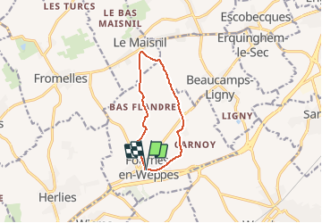
PR en bas Flandre - Fournes en weppes

dehemjacques
User

Length
8.1 km

Max alt
48 m

Uphill gradient
43 m
Km-Effort
8.7 km

Min alt
26 m

Downhill gradient
39 m
Boucle
Yes
Creation date :
2021-03-24 08:57:17.386
Updated on :
2021-03-24 08:58:01.86
1h58
Difficulty : Easy

FREE GPS app for hiking
 SityTrail
IGN / Geographical institutes
SityTrail Plus
The world is yours!
About
Trail On foot of 8.1 km to be discovered at Hauts-de-France, Nord, Fournes-en-Weppes. This trail is proposed by dehemjacques.
Positioning
Country:
France
Region :
Hauts-de-France
Department/Province :
Nord
Municipality :
Fournes-en-Weppes
Location:
Unknown
Start:(Dec)
Start:(UTM)
492070 ; 5603602 (31U) N.
Comments