


PAS DU BERLIOZ

RD78-38
User

Length
9.5 km

Max alt
740 m

Uphill gradient
429 m
Km-Effort
15.2 km

Min alt
487 m

Downhill gradient
430 m
Boucle
No
Creation date :
2021-03-24 09:14:40.0
Updated on :
2021-03-24 14:47:57.155
2h53
Difficulty : Easy

FREE GPS app for hiking
 SityTrail
IGN / Geographical institutes
SityTrail Plus
The world is yours!
About
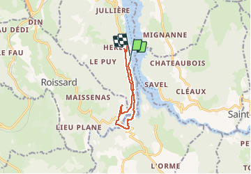
Trail Walking of 9.5 km to be discovered at Auvergne-Rhône-Alpes, Isère, Treffort. This trail is proposed by RD78-38.
Description
Ballade agréable avec vu sur le lac MONTENARD
Positioning
Country:
France
Region :
Auvergne-Rhône-Alpes
Department/Province :
Isère
Municipality :
Treffort
Location:
Unknown
Start:(Dec)
Start:(UTM)
711240 ; 4974304 (31T) N.
Comments