


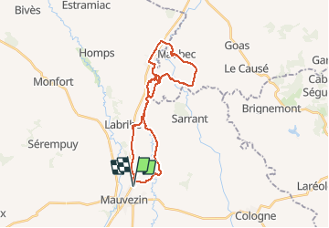
Solomiac-Maubec

lorenzot54
User

Length
29 km

Max alt
193 m

Uphill gradient
345 m
Km-Effort
34 km

Min alt
112 m

Downhill gradient
346 m
Boucle
Yes
Creation date :
2021-03-24 14:53:52.0
Updated on :
2021-03-24 17:17:02.925
1h51
Difficulty : Unknown

FREE GPS app for hiking
 SityTrail
IGN / Geographical institutes
SityTrail Plus
The world is yours!
About
Trail Mountain bike of 29 km to be discovered at Occitania, Gers, Mauvezin. This trail is proposed by lorenzot54.
Description
Rando par lesPR en longeant le ruisseau, très belle vue sur le massif de Pyrénées après Maubec.
Positioning
Country:
France
Region :
Occitania
Department/Province :
Gers
Municipality :
Mauvezin
Location:
Unknown
Start:(Dec)
Start:(UTM)
329762 ; 4844915 (31T) N.
Comments